


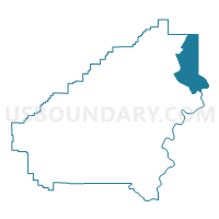
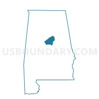
Vincent City Hall, Shelby County, Alabama
About
Outline

Summary
| Unique Area Identifier | 522888 |
| Name | Vincent City Hall |
| County | Shelby County |
| State | Alabama |
| Area (square miles) | 42.01 |
| Land Area (square miles) | 41.08 |
| Water Area (square miles) | 0.93 |
| % of Land Area | 97.78 |
| % of Water Area | 2.22 |
| Latitude of the Internal Point | 33.41627930 |
| Longtitude of the Internal Point | -86.41182710 |
Maps

Graphs
Select a template below for downloading or customizing gragh for Vincent City Hall, Shelby County, Alabama


Neighbors
Neighoring Voting District (by Name) Neighboring Voting District on the Map
- Bethel Bapt, Talladega County, AL
- Harpersville City Hall, Shelby County, AL
- New Life Assembly of God, Shelby County, AL
- New London Fire Dept., St. Clair County, AL
- Turner Hollis American Legion Post #195, Shelby County, AL
- Vandiver Volunteer Fire Department, Shelby County, AL
- Wolf Creek Fire Dept., St. Clair County, AL
Top 10 Neighboring County Subdivision (by Population) Neighboring County Subdivision on the Map
- Chelsea CCD, Shelby County, AL (35,970)
- Moody CCD, St. Clair County, AL (25,023)
- Pell City CCD, St. Clair County, AL (23,885)
- Vincent CCD, Shelby County, AL (5,165)
- Renfroe-Laniers CCD, Talladega County, AL (2,902)
Top 10 Neighboring Place (by Population) Neighboring Place on the Map
Top 10 Neighboring Unified School District (by Population) Neighboring Unified School District on the Map
- Shelby County School District, AL (170,473)
- Talladega County School District, AL (49,716)
- Pell City City School District, AL (27,712)
Top 10 Neighboring State Legislative District Lower Chamber (by Population) Neighboring State Legislative District Lower Chamber on the Map
Top 10 Neighboring State Legislative District Upper Chamber (by Population) Neighboring State Legislative District Upper Chamber on the Map
- State Senate District 15, AL (160,461)
- State Senate District 12, AL (142,431)
- State Senate District 11, AL (125,111)
Top 10 Neighboring 111th Congressional District (by Population) Neighboring 111th Congressional District on the Map
Top 10 Neighboring Census Tract (by Population) Neighboring Census Tract on the Map
- Census Tract 402.03, St. Clair County, AL (6,137)
- Census Tract 402.05, St. Clair County, AL (5,279)
- Census Tract 401.05, St. Clair County, AL (4,372)
- Census Tract 301.02, Shelby County, AL (4,127)
- Census Tract 112, Talladega County, AL (2,902)
- Census Tract 309, Shelby County, AL (2,747)
Top 10 Neighboring 5-Digit ZIP Code Tabulation Area (by Population) Neighboring 5-Digit ZIP Code Tabulation Area on the Map
- 35128, AL (10,197)
- 35147, AL (5,468)
- 35014, AL (4,546)
- 35054, AL (4,101)
- 35178, AL (3,378)
- 35078, AL (2,082)